Saturday, August 9, 2014

Dateline Florence, August 9, 2014

Final blog entry for the trip to Hatteras and the Outer Banks. There wasn't much to post from Thursday. We drove down Hwy 12 to Hatteras Village, and got in line for the ferry to Ocracoke Island at about 9:45. There were two lines of cars ahead of us, and what we figured out was that the ferry could take about one line at a time.


The Hatteras to Ocracoke Ferry is free, and no reservations are needed. A lot of people take this ferry to a very tiny island. I'm told that most of them are just for the day, and they return later. Of course, many of them head directly to the Ocracoke to Cedar Creek Ferry. That one is "reservations required."

As we were being loaded, they were once again filling the line to our left, which meant that there were enough cars waiting to fill 7 ferries!

We waited for about an hour before we were loaded. They don't understand how motorcycles should be loaded, and the guy told us that, since Linda was on a trike, to be on the same ferry we would not be loaded first.

The problem is, if the bike is facing forward, and the boat is rocking side to side, there's a risk that the bike will fall over. Most ferries will put the motorcycles in the front, turned sideways so the rocking of the boat isn't an issue. I secured the bike as best I could and hoped for a smooth ride.

The actual distance, point-to-point, is only a few miles, but because of reefs, rocks and shoals, the boat has to travel in a half-circle, away from the island, then circle to the Ocracoke terminal. It takes about an hour. One guy we spoke with told us he was scheduled on the 1 o'clock to Cedar Creek. The rules call for you to be at the ferry 30 minutes before loading or you can forfeit your reservation, and be put on standby. You don't necessarily get on the next ferry; you get on the next ferry with an opening. Could be the next day!

Ocracoke is 12 miles long. We got off the boat on Ocracoke at about noon, plenty of time for those continuing on to be at the terminal by 12:30, except for the sand dune replenishment halfway down the island. We all got to the village about 12:20, so they got lucky.

As for us, we stopped by the hotel (in sight of the terminal), and parked the bikes, then walked across the street to sMacNally's and took seats at the outdoor bar, facing Silver Lake.


The Shimp Po Boy was great, especially washed down with a couple of Corona's. Linda enjoyed the Shrimp Salad on a Pita roll. We talked with the locals, just enjoying the peace and quiet. Later, after we checked in, we walked around a bit, and found a few stores, even one that sold Ocracoke School paraphenalia, including t-shirts for the Ocracoke Dolphins sports teams ("Beware the Pod!"). It hadn't occurred to me that there would be a school here, but of course there is -- if there are children, there has to be a school, right? I found the OcracokeCurrent, an online news feed for Ocracoke ("WE DON'T CARE WHAT YOU DO, WE JUST WANT TO WRITE ABOUT IT!"). The school graduated 10 seniors this year.!

The next morning, we were up early, and packed, ready to go with plenty of time. Had breakfast at the harbor store (a tiny room behind sMacNally's). The dock dog, a small brown with some lab mixed in, came over to be friends with Linda, who had a danish. I just kept the dog at bay with my foot (no, I didn't kick it, just nudged) to give it the idea that there wasn't any food. The dog just lay down at my feet, with that pathetic look that's supposed to make you feel guilty and share. It didn't work. As soon as someone else came out of the store with a muffin, the dog was up and begging. Not aggressive, just persistent.

We were early for the ferry, and arranged to go on near the front, where they could transverse-park my bike. Great people that work there, helpful, friendly.


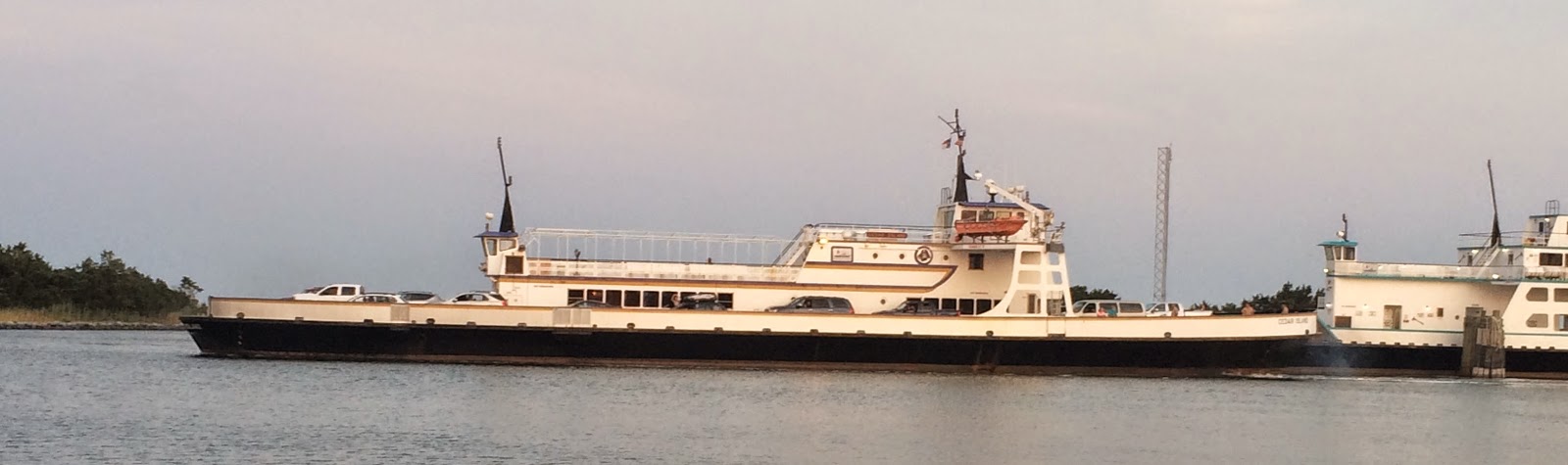
Two different ferry runs depart from here -- on the left, the Cedar Creek departs for Swan Quarter; on the right was our ferry, the Swan Quarter, that traveled to Cedar Creek. Weird, eh?


This is the Cedar Creek, departing for Swan Quarter at 7:30. The Swan Quarter, the newest in the fleet, is to the right.

We were entertained on the 2 hour 15 minute trip by a group of musicians traveling across. Guitars and mandolin strummed out bluegrass, country, and even old Beatles tunes like "Norwegian Wood." Helped to make the time go faster. We were back on the road by 12:30, and headed down Hwy 12 towards Beaufort (in NC, it's pronounced "BO-furt."), about 38 miles away. Beautiful scenery, lots of water with views of the ocean on occasion. A long line of cars with nowhere else to go. followed behind us as we wound our way to the other end of Hwy 12 -- yes, we achieved our goal, and traversed the entire highway -- where we merged onto US 70. By the time we gassed up and had a quick lunch, it was after 1 o'clock before we were on the road.

We had checked the weather for today -- scattered thunderstorms up and down the coast, so we elected to try and make it home rather than risk another day of rainy riding.. We also decided that, rather that go across Road 53, a two-lane blacktop, we'd stick to the main US Highway system. So, from US 70, we headed south on US 17 (towards Myrtle Beach), then at Wilmington, we headed West on US 76/US 74, arriving at 4 o'clock, the beginning of Friday's rush hour. We had a bit of delay, but we made up time once we were pointing west. Apparently they're working to make the 74/76 highway into part of the Interstate system, and it's smooth, four-lane, and fast. We were rolling along at 75 mph at one point (in the 70 mph zone), and the miles disappeared in the rear-view mirror quickly. By 5:30 we were crossing into South Carolina, south of Fair Bluff, and we arrived home at 6:30. A long day, but only 5 hours of riding, and we traveled about 280 miles, start to finish, and average of 56 mph.

All in all, a great week, lots of great food, terrific rides, interesting sites, wonderful, friendly people everywhere. Linda, as always, is the perfect travel companion, ride partner, teammate. I'm already looking forward to our next adventure!


Thursday, August 7, 2014

Dateline Buxton, NC, August 7, 2014

Wednesday was as good as it gets, weather-wise. No more than a 20% chance of isolated thunderstorms, high expected to be 81° and lots of sunshine. Let's ride!

After wiping down the bikes, cleaning off the rain-spatter and making them shine, we headed out around 9. Our goal: the northernmost tip of NC Hwy 12, above Corolla. It's about 84 miles north of our hotel.


In the bright sunshine, we got to see what we'd missed coming in on Sunday. You can see it on the map, but you can't really get it until you're on it. The road from Hatteras Island to Kill Devil Hills is a sandbar, with small areas of wide spots that people have built villages on. Throughout most of that section, the Pamlico Sound is visible to the west, but the view of the Atlantic Ocean to the east is blocked by sand dunes 20 feet high in places, most of them naturally formed from the constant wind pushing the sand towards the land. At this time of year there is a constant flow of traffic, north and south bound, and cars parked on the shoulder for much of the 45 miles between Buxton and Kill Devil Hills. These brave souls have to park, then climb the dunes with their beach paraphernalia, or hike through the scrub to get to the Sound.

In August of 2011, Hurricane Irene roared across the Outer Banks, cutting a new inlet across Pea Island (named for the peas that used to be grown here). North Carolina officials rushed to build a "temporary" bridge to reconnect the two sides. 


I tried to find an image from Google Map's street view to show you this, as it is about as rag-tag a bridge as you'll ever see. Corrugated steel plates that appear to have (at one time) been covered with concrete create a patchwork road surface; steel railings are reinforced with wooden beams. The locals call it the "Lego Bridge," laughing at the term "temporary." Road crews are constantly reinforcing the ocean side where nature continues to cut away at the land. And critics are recommending a ferry system instead (source: New York Times). I didn't get the pleasure of seeing this emergency repair on the way down due to the driving rain. When you're on the bridge, you can see how it got its nickname.

At the northern tip of Pea Island is the Oregon Inlet, created from a hurricane in 1846 that swept across Nags Head. The Bonner Bridge is 2.7 miles long, connecting Pea Island to Bodie Island.


It's a beautiful bridge with long sweep causeways with  a raised bridge in the center. The Department of Transportation has given it a 4 out of 100 safety rating, and everyone agrees it must be replaced. The problem is, no one can agree on the options, one of which is a 17-mile bridge that would parallel Hwy 12 from Bodie Island to Rodanthe, on Hatteras Island, bypassing Pea Island altogether (Source: Surfline.com).

We continued north along Hwy 12 through Nags Head, Kill Devil Hills, and Kitty Hawk. It's a picturesque ride for the most part, with most residences resembling Cape Code style houses on stilts. The speed limit is 35 mph, and about every 100 yards are crosswalks. NC law required vehicles to stop for pedestrians in these crosswalks so it was slow going all the way through. The temperature had risen to about 83° by this time, and the humidity was high, so it was getting warm.

We passed through the town of Duck, a large area with a 25 mph speed limit, and the only police car I've seen all week, sitting on the side of the road with an officer watching the radar.

Finally, we reach Corolla, and except for the hotels and rentals, the only thing that stood out is a bright yellow strip mall. When we approached the end of the highway, we began seeing new signs (newer than the Street View in Google Maps): "Only vehicles with 4-wheel drive allowed ahead," "Lower the air in your tires to drive on the beach," and such. Almost there!

As we rolled around the curves, the sand encroachment on the road brought it down to a single lane, and we finally arrived at the end of the pavement.


Apparently, they consider the beach to be part of the road for another several miles, but there was no way I was going to take the bikes out there. Here's a close-up of the signs on the right:


I would have like to parked and walked out for more pictures, but as you can see, that would have been a no-no.We did reach our goal, so we turned around in the sand-covered road and made our way back. It was about 12:30, 3½ hours after we started, and we were getting hungry. 

Stopping at a convenience store down the road for water, we asked the clerks for a decent place to eat lunch. They suggested Uncle Ike's, just down the road on the left. "You can't miss it," he said.

Here's a picture from highway 12. Behind the trees on the left, you can see the red awning. I think that's Uncle Ike's. And yes, we missed it.


We continued south, back to Duck, where we found the Sunset Grill & Raw Bar, and stopped for lunch and air conditioning (the temp, supposed to be 81°, was 88°). It was a good choice. There's a beautiful view of the Currituck Sound, and the land you see across the water is a peninsula, jutting out from the mainland.


Linda enjoyed a Seafood Roll, "Homemade seafood salad consiting of shrimp, lobster, langostino and white fish on a New England soft roll." Actually there were two, and she reports they were really good. I had a Yellowfin Tuna sandwich, with a fresh tuna steak. I may not be able to go back to canned tuna! 

Cooled down and hydrated, we sprayed ourselves with SPF 50 and headed south. We cheated a bit, taking Hwy 158, a 4-lane, 50 mph highway through Kitty Hawk, Kill Devil Hills (past the Wright Brothers Memorial -- impressive), and cut back to Hwy 12 in Nags Head. There we encountered a thunderstorm to the west, and rode through what we thought might be a drencher that only lasted a few minutes, cooling us off. 

Back on Hwy 12 and southbound, we encountered several brushes with the storm (we later found out there was an official thunderstorm warning), and headed back south to the hotel, arriving around 4. Total trip was about 190 miles, and 7 hours. A good day's ride.

We felt better after showering, but had to wait to go to dinner. Apparently the storm caught up with us, and it was raining hard. We finally headed out at 8, over to the Diamond Shoals Restaurant, where Linda had shrimp and scallops, and I had what was supposed to be an 8 oz sirloin that I think was more like 12, and a skewer of barbeque'd shrimp. So much food, we couldn't finish, but it was good.

We've changed our plans. Today we'll take the ferry over to Ocracoke Island, but we're going to spend the line at the Anchorage Inn, right on Silver Lake, minutes from the Cedar Island Ferry. We've got our reservation for the 10 am ride on Friday, so we'll have the day in the little village at the southern tip of the island.


Wednesday, August 6, 2014

Dateline Buxton, NC August 6, 2014

Weather started improving yesterday. Very cloudy, 60% chance of isolated or scattered storms. Not enough to stop our intrepid explorers. We carried our rain coats just in case.

After breakfast at Diamond Shoals Restaurant, we took the short ride to the Cape Hatteras Lighthouse. It's listed as the tallest brick lighthouse in North America. It's a beautiful structure, and a nice area to visit.

In 1870 the lighthouse was positioned 1,500 feet from the ocean. By 1970, the natural erosion that occurs in the Outer Banks had pushed the shore back until there were only 120 feet remaining. In 1999 the lighthouse was moved 2,900 feet to its present location, 1,600 feet from the shore.


When we left the lighthouse area, we headed to the end of the road, where we found a beach entrance. Very wide, and off to the right were cars and pickups; you can get a permit to ride on the beaches here.


I'm still looking to find a new pair of riding gloves to replace the ones I destroyed on the trip up here (rain and leather really don't work well together). There is, according to Google, a place called Island Choppers on Highway 12 in Frisco, south of here. So we headed south. 

We got to where the store was supposed to be, and found a tattoo parlor instead. When I checked in at a sporting goods store, they told me that Island Choppers had moved to Buxton. Well, we'll check it out on the way back, but we continued south to see where the ferry to Ockracoke Island would be. 

There were times along the road that we could see the ocean on the left, and the sound on the right as we headed for land's end. We continued on past the ferry, and went to the point, where the Graveyard of the Atlantic museum is located. Standing in the parking lot, there was water on three sides of us. 


This museum is mostly displays about the wrecks around the Civil War era, but there were references to over 30 wrecks that were the result of German U-Boat attacks during World War II. I didn't realize that they were this close to the US coast. 

One item of interest was about the electrification of the island. Hatteras Village got electricity in the mid (Southern tip of the island1930's; the rest of the island had to wait until the early 1950's. Source: Hatteras Guide.


In the entrance to the museum, you can see the original light from the Hatteras Lighthouse. Many of the fresnel lens sections have been removed, but it's still in pretty good shape.

We headed back north, and never found Island Choppers as we passed the hotel and continued up to Avon.
 We did go through patches of rain, some light, some heavier, but each quit after a mile or so. We passed the hotel and headed north. Avon is a wide spot in the road, just before the long stretch that takes you to Kill Devil Hills. We stopped before heading further (that's on deck for today).

I called the number for Island Choppers, only to find it disconnected. Oh, well. We headed back towards Buxton and stopped at the Froggy Dog for a late lunch. Excellent food -- Linda said her hand-made crab cake was delicious, and the barbecue chicken sandwich was terrific. We watched the bartender struggle to bring one of the taps on line, and she kept running pitcher after pitcher of foam. My first thought was too much pressure.  I called my friend Jimmy Deaton from Southern Hops to ask him what may be the problem. He concurred, and advised what may help. I think she was reluctant to try it, but hey, I tried.

Too much good food, and we really didn't get hungry last night. We decided not to go out for dinner. 

Today, it's supposed to be sunny and 81° so we're heading north to Nag's Head and beyond, to see what we can see. Should be the best day of the trip.


Tuesday, August 5, 2014

Dateline Buxton NC August 5,2014

Yesterday was a washout -- literally. It rained all day, making touring by motorcycle a general pain. We did get some things done, though.

When I made the reservations here, it didn't occur to me that the hotel had no elevator. With Linda's arthritic knees, climbing the stairs to the second floor (and back down again), is painful -- for her to do, for me to watch.

I stopped at the desk Monday morning, and discussed it with the manager. They were very accommodating, and had us a new room within a few hours. They even offered help to move the luggage. OK, it was after I had lugged it all back down again, but it's the thought that counts, isn't it?

By the time we got settled in, it was time for lunch. Still raining, we donned our rain coats and walked to the Diamond Shoals Restaurant, just down the road. Nice place, the food was delicious. Linda said her grilled grouper was excellent, and the fried clam strips I decided on were perfectly done. I had to have a cup of their "Award Winning" clam chowder. Creamy, loaded with clam, delicious! I had a few of Weeping Radish's Black Radish beer. Dark and tasty, very smooth. We sat next to a couple from New York that were staying at the hotel. They drove over (remember, within easy walking distance) in their 2014 Camaro convertible.

Back to the room for a quick nap, and when we looked out, the rain had stopped. We suited up (the bikes were still wet) and headed down the road on the trike to Conner's, what appears to be the only supermarket on the island. It looks like they just put the groceries up wherever they chose, with no rhyme or reason. Groceries in the trunk, we continued south on Highway 12 for a few miles, just happy to be riding. The maps showed some nasty showers coming back in, so we didn't go far.

The Hatteras Island Inn claims to have "WiFi in the lobby." They're not kidding. While we were on the second floor we were able to hijack the neighbor's wifi, but it was very slow. Now, on the other side of the hotel, there isn't any connection available. I'm using my iPhone hotspot when I need to (and I needed it for work yesterday, so I'm really glad I have it).

I've been working with Garmin's Base Camp mapping software, and since its base map doesn't have much detail for Hatteras Island, every route I try to calculate shows a straight line, "as the crow flies." I did learn how to import tracks from Google Maps, but when I convert them, they straighten right out. Frustrating.

We're heading out soon while the weather holds. The weather calls for Scattered and/or Isolated storms today, so we won't go too far, and we'll carry the suits. There's a place called Island Choppers, where I want to look for new riding gloves (the rain destroyed my other ones), and new glasses (lost a nose guard). The Lighthouse is just down the road, so we're probably going there as well. The picture is from the observation tower in the hotel.


Tomorrow's weather is our best shot for a ride up to Corona. Fingers crossed!

I found this Buxton Visitor's Guide this morning, thought I'd give it a link.

Sunday, August 3, 2014

Dateline Buxton, North Carolina, August 3rd

At the end of may last post, I suggested that we would have an "easy ride" today. Well, it was only 179 miles, around 4 hours. But that doesn't count the rain.

It was raining in Goldsboro when we went down to breakfast, and the forecast wasn't very good. It was nice of the Country Inn hosts to let us park under the front canopy; as wet as they were when we got there, covering them would have been useless.


We never met the rider with the White Goldwing Aspenglide and just parked around him. Kinda patriotic, no?

We packed up, put on the rainsuits and headed out around 8:30, letting the Garmin direct us to US Highway 13 North. I changed my mind on the actual route, and decided to follow 13 all the way to US 64. Garmin pestered me for over 10 miles until it finally gave up and waited for me to get back on track.

The rain never stopped; it went from a light mist to a steady shower, but it rained all day. We had to stop and clean the glasses and face shields a few times as the water found its way to the inside. The roads were in good shape but I kept to the speed limit to be safe. In fact, on the sections of 13 and 64 that were 70 mph, I kept to 60 (in the right lane, of course).

We had to a-holes that cut us off, but I could see it coming and reacted well in time to avoid trouble. I think that, if we'd been in sunshine, the ride would have been terrific. It was work.

We finally got within striking distance of the Outer Banks, and hit the "Lindsay C Warren" Alligator River Bridge, a draw bridge over the Alligator River to the Alligator River Wildlife Refuge. The ride is nice, through the trees (in the sun). We were constantly barraged with oncoming traffic as the previous week's tourists were leaving. More water thrown at us (wipe the shields, keep going). The center of the bridge, where it opens, is corrugated steel plate, not the most pleasant thing to cross on two wheels.

On the other side of the refuge, the Virginia Dare Memorial Bridge crosses the Croatan Sound. If you don't know, Virginia Dare was the first child of English parentage born in the New World. She was part of the Lost Colony of Roanoke. The entire structure, causeway and bridge, is over 5 miles long, and curves gracefully over the water. A little nerve wracking in that there was a sign "Subject to Cross Winds." Just what we need in the rain.

Finally, connecting Roanoke Island to Cape Hatteras is the Washington Baum Bridge, less than 500 feet long. Immediately at the end, a hairy little turn onto Highway 12, and we were 47 miles from Buxton, our destination.

I know I've said it before, but this would be so cool in sunshine and dry roads. You travel down through the Cape Hatteras National Park, along a very thin strip of land on a two-lane black top, passing through tiny little communities. But the traffic moved slowly, there were spots where water covered the road, and visibility was very poor, as nature saved its best for last as the rain came down harder as we closed in on Buxton.

Soon enough, we arrived at Hatteras Island Inn, and checked in just after 1.And, of course, you guessed it -- the rain came (almost) to a stop, certainly much less than it had been, as soon as we got in our room.

We got the bikes unpacked, and walked across the street to the "Shipwreck Grill," where one is tempted to ask, "what's it like to work when you're high?" So, you  say I was tired, and therefore too critical? Let's see: I checked my phone when we sat down at 2. At 2:15 I asked a passing waiter if we might get some menus to look at. At 2:20 our waitress stopped by and took our order, which she got wrong. By that time, we ate it anyway. Linda said the burger had no flavor, I had slaw on my barbeque (didn't ask for it) and she had fries instead of the slaw she asked for. The waitress never came around to refill our glasses, and finally stopped by with the check at 3 -- the wrong check.

We hit a grocery store for milk an essentials, and headed back to the hotel. We're probably in for the night, as we both look like we've been "rode hard and put up wet." Hey! I think we were!

Honestly? We knew we were going to be challenged on this run. It's part of the excitement of riding the bikes to new places. Yes, it was stressful. I had to use all of my training, my experience and my skill, pay attention ahead, watch Linda's travel (yes, I will always worry, even though she's an excellent rider), keep wiping the face shield (inside and out). But, we made it, safe and sound, and the adventure is just beginning.

Saturday, August 2, 2014

Outer Banks -- August 2 - 8, 2014

Dateline Goldsboro, NC, August 2nd.

I've heard it said many times: "If you ride a Goldwing, you don't get wet." OK, we're going to get to put that saying to the test. In the next few days, the forecast between Florence and the Outer Banks is for Scattered or Isolated Thunderstorms, between 20% and 60%, depending on the time of day. Well, that's why we bought the rain suits; now we'll try 'em out.

We ridden in the rain before, from sprinkles to downpours. I've had to dry out my wallet until I started tossing everything in the trunk if there was a chance I'd be riding in the rain. You just have to take it slow, ease around the corners, and watch out for the other guy. But this is the first trip we're taking in the rain.

We're avoiding the Interstate, especially since I find I-95 through North Carolina to be about the worst road to travel. So we're going through Marion & Mullins, up the US Highway system, through Goldsboro, then up to US 64, and across to Kill Devil Hills, before heading south to Hatteras.

Here is a link to the Google Map for the route.

We left the house at about 9 this morning. Temperature was 70° and the humidity felt like 90.  We ran through small pockets of rain every couple of miles. Not enough to get our clothes wet, but the windshields would start throwing water over the top and splash on the face screens. So, our faces got wet, but as long as we were moving forward, the rest of us stayed pretty dry.

We rolled on through Marion, Mullins, Nichols, then crossed the border into North Carolina. It struck me that, right at the border, there was a small section of road that had not been repaved; must be a disagreement over who should spend the money to pave 50 feet of road!

On through Fair Bluff, Cerro Gordo, Chadburn to Whiteville, where we turned north on 701. We were getting a bit hungry, but we had to travel several miles to Clarkton, where we stopped for a quick bite and put on the rain jackets. It wasn't so much the rain as the chill from the damp air.

The ride through the country, with all the small towns and picturesque landscape, is a much better way to travel than the Interstate, even if the rain dampened our enthusiasm a bit (pardon the pun). Knowing we would be traveling slower than normal, we planned to stop around halfway for the night. We've got the whole week, and we're in no rush.

As it turned out, by the time we reached Goldsboro, the on and off rain along with the traffic we were tired enough to decide to stop. We checked in at the Country Inns and Suites in Goldsboro. The chain has always been a good place to stop, and the AARP rate of $89 was a welcome addition.

As it turns out, the rain caught up with us within 30 minutes of checking in, and it's raining now. We'll get a nice dinner later, a good night's sleep, and an easy ride to Hatteras in the morning.

Sunday, May 11, 2014

Myrtle Beach Bike Week -- First Weekend, May 9-11, Murrell's Inlet, SC

At the last minute, we decided that this year, instead of riding down for the day, we would spend the weekend and enjoy thesights and sounds of Bike Week. Officially, it doesn't start until Monday, but many of the vendors were already here, and there was a lot going on.

Thursday night I started looking for a place to stay, almost expecting to find a room in a 1-star dive at an outrageous price. Surprisingly, there were still a lot of available rooms, even if the prices were starting to climb. I use the travel sites (hotel.com, Expedia, etc) to find the places we want to look at. But after our experience with Travelocity (the Miranda Lambert concert trip to Columbia), I usually go to the hotel's site to book the room.

One place popped up in several searches: Festiva's Ellington at Wachesaw East. Just off US 17 in Murrell's Inlet, it looked like a golf resort, and we found a "King Villa" for a decent price. It's posted in every travel site, but the direct link to the resort doesn't work. The link above is to the parent company, Festiva Hospitality Group, and even their link doesn't work.

We packed the bikes Friday morning, and after work headed directly to the beach, starting out around four o'clock. Here's the route. Traffic wasn't too bad, and we rolled through Florence and Marion counties pretty quickly. Even Aynor, normally a bottleneck in Horry County, was still pretty smooth. I didn't count on hitting Conway at 5 o'clock, and we hit the rush hour traffic there. It took a bit of stop and go, but soon enough, we were over the Intercoastal Waterway and headed down Highway 544. While the basic directions will take you down to US 17 right in the middle of all of the beach traffic, we turn off onto 707 that takes you straight to Murrell's Inlet and, as it turns out, about a half-mile from our destination.

Apparently, this place is a huge condo village, half of it private, the other half time shares or such. The "King Villa" is actually a one-bedroom apartment at the end of a 16-unit building, in a section with 8 buildings surrounding a pool.

There's a screen porch for each unit (there's a ceiling fan above)

The living area is good sized, with a full kitchen area and sitting room.

The bedroom is small, filled with a king-sized bed.

There was a TV (in the cabinet on the right), and another in the bedroom, but they were the older, 21" CRT units --no flat screen, no hi-def. Haven't seen them in quite a while. No matter, we weren't here to watch TV anyway (we'll catch up with the DVR later).


By the time we got settled in, we decided to just run to the Food Lion, pick up the groceries we needed and eat in. We got to bed early.

Linda had suggested that, since we would be here for the weekend, that we should try taking one of the guided rides available during bike week. She found MyrtleBeachBikeWeek.comhttp://www.myrtlebeachbikeweek.com/ and found that there was a ride for Saturday -- the "Northern Route," taking us to the Conway Historic District, then to La Belle Amie Winery, back to Medieval Times, and finally to the Myrtle Beach Speedway. About 100 miles of a group ride through the country.

The ride was to start at Inlet Mall, about two miles north of our rooms, and we got there a bit early not knowing what to expect. We met Sonny Copeland, the coordinator of the ride, and signed up. Sonny is a genuinely nice guy, and we had a nice talk with him. Linda actually helped him sign up the riders as they came in.

Sonny had his pre-ride instructions about 10:15, with about thirty riders. While this was a guided ride, it wasn't going to be like the ones we've done before (the toy runs, especially), where the intersections are blocked by the police so we can stay together. As Sonny said, "We won't be running any red lights. If the light turns red, stop. But I will become the slowest thing on the road until everyone catches up again." I was beginning to wonder how this was going to go. But everything is an adventure, and I have my Garmin, so no worries about getting lost.

Here's the route map (as best I can recall).

The temperature was around 85, but the high humidity made it seem hotter. We headed back up 544 toward Conway, stopping at a station for gas, and drawing the first card. This wasn't a poker run, but the high hand would get the pole position at the speedway. As we left the station, we did split up. True to his word, Sonny slowed down -- way down, until the rest of the pack caught up. Then back up to speed.

We ran into a lot of traffic around Coastal Carolina -- Graduation Day. We stayed together though, and headed down to the river at Conway's River Walk. We pulled up under the overpass in the shade, and walked out on the deck overlooking the river.

Sonny pointed out some of the interesting things about the area, how the river was a main route for transporting goods to Conway. He assured the out-of-towners that the black water wasn't pollution, but rather the result of the cedar trees, like many of the waterways in this area. Some were fascinated by the Spanish moss that hangs from the trees, a parasite that feeds off the trees.


This the overpass that we traveled to get down to the river.  It's a nice, peaceful area, and the scenery is beautiful. I'm told the fishing is good here as well -- bass, brim, crappie, catfish.


We picked another card here (Linda became Sonny's assistant), and headed out to the country, on the way to La Bell Amie Winery.


If you've read my previous entries, you may recall that La Bell Amie Winery is a favorite of ours, so we looked forward to visiting. Sonny took us through the country, up highway 905. We got separated, and spent most of this leg of the ride in two groups, but since it was a straight ride for 30 miles or so, Sonny kept up the pace. Before we turned off onto highway 9, he waited for the group to catch up.

As we turned into the winery, we realized that, as on most Saturdays in the Spring and Summer months, there was an outdoor "Music Festival." In this case, it was a guy with a Karaoke setup singing songs from the 60's. The crowd was mostly older (OK, our age), and they were enjoying it. we parked around the circle, and Miss Vicky, the owner, explained the name of the winery (named after her mother), and welcomed us graciously.

 We headed inside and bought some wine -- half white, half red, and sat in the shade taking a break.Several of the visitors came by the bikes, and really took an interest in Linda's trike.


Sonny had advised us that we had to leave by 1:30 to stay on schedule. Otherwise, we might miss our opportunity at the Speedway. He tried to gather us up to leave, but there were a few stragglers that weren't paying attention. When he'd waited long enough, he moved out, and we hit the road. It didn't take them long to catch up!

We headed back down to highway 31 (the highway 17 bypass' bypass), and down to Medieval Times, out near the Hard Rock park area on US 501 (now bankrupt for the second time). We were given a private tour with discount offers for the show. We've got to get there one of these days -- it's a huge place, and I'm told the food is delicious. Jennifer showed us around, telling us a bit about the place. We didn't get a chance to see any of the rehearsals, as sometimes happens. But you can see the arena area is quite large.

We drew our cards (Linda and I were pretty much out of the running by now), and the high hand (out of four cards) was three tens. He got the pole position (he didn't get to keep it, though).


We came out from the Medieval Times site and followed the frontage roads around highway 501 to Myrtle Beach Speedway, where we headed for pit row and  lined up behind the pace car. We were back about the 4th row, and the pace car headed out, starting slowly (about 35 mph). Sonny gave us the rules: Don't pass the pace car, for the first lap, stay in line (for pictures), then have fun.

After the first lap, Linda did just that as she accelerated, passing other riders and riding higher up the banked curves. I could see her grin in her mirrors as I followed her. As the pace car saw we were doing ok, he began speeding up. We were hitting about 50 around the banks, and climbed toward the wall. I was counter-steering as I accelerated through the turns, seemingly horizontal on the banks. It was thrilling, well worth the $20 price of the ride. As the pace car pulled us back to pit row, we were on top of the last rider, just making her last lap. One more and we would have lapped her!

Last cards were drawn, and the winners received prizes. We thanked Sonny, and headed out, back to the room where we cleaned up a bit before heading to dinner.

We took just the trike and headed to the Dead Dog Saloon out on the Marsh Walk for dinner. I thought it would be more like Creek Ratz next door -- fried fish and bar food. This was much better: excellent filet, and Linda included the shrimp and scallops. Our timing was good -- as we got our food, the crowds began to come in.

From here, we drove down the road to Suck, Bang, Blow, one of the many biker bars along the 17 business road in Murrell's Inlet, one of our favorites. It's like a box of chocolates: you never know what you're gonna get. We didn't stay long, but we had a good time.

And now, for your entertainment (and mine), the Girls of Suck Bang Blow:


We headed back to the room, and crashed, heading to bed early.

Today is kind of open. I want to head up to Barefoot Landing, where there's usually a lot of vendor exhibits, the back home again.

I'm told that the vendor permits this year have been more restrictive, in that the normal outside setups can't be done until Monday (providing the permanent establishments the opportunity to entice the visitors first), so we didn't see a lot of the normal stuff. But things were shaping up, and some of the "tent stores" were popping up in Murrell's Inlet.

Friday, March 14, 2014

Thursday, March 13th

Even though the weather reports promised the temperature drop, it was a bit surprising to step out on the patio this morning to 45°! The original expectation was sunny, breezy, and temps around 60°. Sounds like great weather for a long ride.

On the news was a report from Iron Horse Saloon. Apparently, early this morning, three people were crossing the street when a woman ran them down, injuring them seriously. She was taken away in cuffs, and later was charged with DUI, as 4 hours after the incident she had a BAL of 0.104.

This is why we don't like to go out to the events after dark during Bike Week. While no motorcycles were involved, there are plenty of drunks out there. Better to enjoy in the daylight.

After breakfast we finished our packing and I stuffed the bikes with the bags, leaving little room (Dad always said, "Don't pack any air -- there's plenty where you're going.") for anything else. We checked out and headed up US 1 to I-95 above Bunnel. We were going to take the A1A up the coast, but with the temperatures and wind, decided that doubling our travel time just to get above Jacksonville was not going to be as much fun. We were 68 miles south of Jacksonville when we got on the interstate, and the temperature was 55°, where it would remain for the rest of the day. The wind was strong, and kept changing directions. Add to that the backwash from the trucks and campers, and we felt like we were getting beaten for a hundred miles.

We followed 295 around Jacksonville, reversing out route from the trip down. The wind over the St. John's River bridge threatened to push us into the next lane, and the temperature at the top was only 52­°.  We stopped for lunch just north of Jacksonville, more so we could warm up a bit.

The second hundred miles were no better as the temperature never rose and the wind never abated. Finally as we approached Savannah, I decided it just wasn't worth the constant pummeling we were enduring, and found a Hampton Inn in Richmond Hill, just south of Savannah.

We checked in, and cleaned up. At 5 there was a "manager's reception" in the lobby, with barbecued ribs and chips 'n salsa, beer and soft drinks. This became dinner, and we we entertained by Angel, one of the assistant managers, as she told us stories about her family, her father retired military and her mother from Jamaica.

We're hoping for better temperatures and calmer winds for Friday, and we went to bed early, very tired from the ride.
Wednesday, March 12th

Looking out from our room at about 5 this morning, you could see the promised rain, soaking the roads, still splashing in the pool at the next hotel. Weather reports indicated that the rains (no thunderstorms) would continue until around noon. Then the clouds would lighten, the sun would poke through, and the temperature would rise -- for the day.

So, this was a good time for laundry, so we're not carrying home dirty clothes. Just about the time the wash was done and folded, the sun came out. Temperature was around 68°, and it was lunchtime.

The wind dried the roads quickly, and we headed south on the A1A  for 16 miles to the lighthouse area at Ponce Inlet.

We've visited the lighthouse before -- very nice. In operation since 1887, the 175 foot tower can be seen rising about the scrub trees as you wind your way around to the entrance. It looked busy today, with cars and motorcycles in the parking lot.

We continued past, to the  Hidden Treasure Rum Bar and Grill, for lunch.


Sitting on the waterfront, truly in the shadow of the lighthouse, this place is a find. Great seafood, friendly, happy people and staff, we enjoyed the sun and the wind for our last day before heading out in the morning.

As promised, the temperature soared to around 85°, tempered only by the wind. It howled between the hotels, shifting directions and shoving the bikes around. The speed limit is 35 mph on this section of the A1A, so it wasn't difficult controlling the bikes, but it was necessary to pay attention as the wind shifted constantly.

Not much else to report for Wednesday. We've covered about as much as we set out to do, and have had a great time. We prepared for the ride home by getting some of the packing done. It takes a little more to pack for motorcycles, as you have to take advantage of every square inch of storage space.

Wednesday, March 12, 2014

Tuesday, March 11th

We went down to breakfast this morning around 9 or so, to a packed house. After walking the buffet line, I looked around and, finding no empty tables, asked a couple if we could share their table. They graciously agreed, and we had a nice time with Kevin and Jennifer from Toronto. Having seen pictures of the snow they've had this winter, we had plenty to talk about.

Kevin tells me they're running out of places to put the snow after the roads and parking lots have been plowed. He's learned a new phrase -- "Ice Quake," as the ice shifts and cracks. As crummy a winter as we've had in South Carolina, hearing about those north of us and their experiences makes ours not as bad.

We headed out around 10, down to International Speedway Blvd, to a music store. I wanted to see if they had a Martin "Backpacker" guitar, a small-bodied, full-fretted unit that is easily carried. In Florence, the music stores can order it, but don't keep one in stock.


They had one, a used one with nylon strings. The salesman thought that Martin had stopped making them, until he went online and found them. They're available from Amazon, with steel or nylon strings. It does have a nice sound. I'm more intrigued by the Traveler guitar, also available from Amazon:


Steel Strings, piezo pickup, removable lap rest and standard strap pins, this unit can fit in an overhead compartment on an airplane. The ratings are 4 and 5 stars.

Leaving there, we turned north on US 1 and headed out to "The World Famous Iron Horse Saloon."  We arrived around 11:30, and there was still plenty of places to park (for free) on site. Later, people would be paying to park in nearby lots.


We got the souvenir shopping out of the way early and stuffed the T-shirts into the trunk before heading down to the stage, where The Porch Dogs were setting up to play. They bill themselves as a "Cajun/Zydeco" band, playing old favorites like "Louisiana Saturday Night," "Diggy Diggy Do," "Jambalya" and more. They saw Linda's shamrock tattoo, and launched into a traditional Irish tune as well. They did a rendition of "The Devil Went Down to Georgia," with Bo (the fiddle player), using an adolescent voice to do the parts where Johnny replies to the devil. Very funny. But his fiddle playing was as good as any we've heard.


Since they were on early, as the riders came in, not many people were down at the stage until later in their set. It was almost like a concert just for us, and we had fun interacting with them. When Kim came down to the stage, she shuffle-danced and laughed as they played.


What you can't see in her back pocket are a riding crop, a flogger and a cat-o'-nine-tails. I never asked her why. In the picture above, you can see the washboard vest the accordion player is wearing. She asked, and he let her put it on, handing her two bottle caps to play it. She played it for a little bit, then came over and put it on me. Who's gonna argue with a girl with whips?


I played along with one song, then returned it. Later, the accordion player used it to play along with Bo to "Dueling Banjos."

As people came over, the stands filled up a bit more, and this little girl enjoyed dancing to the Zydeco beat.


It's the kind of music that makes you tap your feet, laugh and enjoy. My kind of good time.

As the next band, JB Walker and the Cheap Whiskey Band set up , Linda and I went over to the picnic tables and ordered a half-rack of ribs (beef) to share. They chopped the rack into individual ribs, and put them in a Styrofoam container. the kind with the large section and two small sections. The ribs are naked, and you add the sauce of your choice, from sweet, smokey and hot. Instead, I squirted the sweet into one section (for Linda), and mixed the hot and smokey in the other. They were delicious, and we listened to the band from there.

JB Walker and the Cheap Whiskey Band played Classic and Southern Rock standards, like Marshall Tucker's "Can't You See" and the like. JB's been in the business for a long time, and his raspy voice makes you think he's been drinking the cheap whiskey for all that time. The music was good. His singing was less than that. But most of the people there seemed to enjoy it.


This image came from the 2nd story deck that stretches across the area. Lots of shaded areas, three bars (including one that was fashioned from an old yellow school bus), but not a lot of seating, all of which was taken.

We left around three and headed back to the hotel for a while. Later, knowing we needed to eat something, we decided to find a place to eat, and went to Dimitri's Bar Deck and Grill, on Atlantic Ave not too far from the hotel. The food was very good -- Linda had the traditional Gyro, while I opted for a Roast Beef and Chedder Melt on a Ciabatta roll -- and plenty of it. We couldn't eat it all.

If you recall, on Saturday we went to Publix where we bought some Keurig coffee pods that didn't seem to get back to the hotel. On Sunday we went back and explained the situation, and they let us pick another one up. Well, while putting something in Linda's trunk, I found the original box of pods. It had fallen out of the bag and ended up behind something else. We headed over there and returned the box to them, to their surprise.

Back to the hotel, a glass of wine or two, and an early night. The fresh ocean air, the warm temperatures and the riding and walking are conspiring to wear us out. But we are having a good time!

Wednesday started out with showers. It's about 9 o'clock now, and it looks dry out there. Don't know yet what we're up to, though. I'll let you know tomorrow.

Tuesday, March 11, 2014

Monday, March 11, 2014

When we mentioned to other riders that we were headed up the A1A to St. Augustine, they all had the same reaction: "Oh, we just love St. Augustine!" That seems to be the general consensus. It's referred to as "The Oldest City." Founded in September 1565 (fifty-five years before the Pilgrims landed at Plymouth Rock) by Don Pedro Menedez de Aviles of Spain, it is the oldest, continuously occupied city in North America. The historic district is rich in the Spanish, English and early American influences, as well as the development in the 1800's by  the railroad tycoon Henry Flagler as he built hotels to house his friends and guests as they traveled (on his railroad, of course) to escape the northeast winters.

Temperature was in the high 60's as we headed out from the hotel, and followed the A1A, the coast road along the eastern shore of Florida. With the Atlantic Ocean on our right, and for some of the route the Halifax River on our left, the blue skies and white wispy cloud cover made the trip enjoyable. We weren't the only ones, as a constant stream of motorcycles and cars streamed north and south along the way.

We crossed the Bridge of Lions into downtown St. Augustine, and turned north in an attempt to park at the Castillo de San Marcos. Construction began in 1672, and it's still an imposing landmark.

We had a destination in mind, the Panama Hat Company on St. George's Street. When we were here in December, I found a hat that actually fit my head (most hats are sized up to 7-5/8; my head is 7-7/8). Unfortunately, Linda spent too much time shopping, and I changed my mind. After the winter we had, I kept wishing I had that hat.

The parking lot at the castle was full, with several cars circling like buzzards, waiting for someone to leave. Instead of joining the flock, we turned out of the lot and headed up the block, turning into town at the City Gates, built in 1704 as part of the Cubo line, an earthen wall fortified by palmetto logs that surrounded the city, and was built to keep out invaders, Indians, and wild animals.The gates are still standing.

This is the only downside of visiting St. Augustine -- the parking situation. Free parking is limited, and restricted to patrons of the shops. Paid parking is usually full. We rode south, until I looked across and saw we were back at the bridge. I turned and went around for another pass. Finally making a turn that I thought would be a waste of time when I was forced to turn again after one block, I was forced to turn in to a small alley, that opened to a small paid parking lot where Linda saw the single "Motorcycle Parking Only" spot. After feeding the meter, we walked out to the street, which happened to be Hypolita St, one block east of St. George's!

St. George's street is now a pedestrian walkway, really to narrow to accommodate vehicles and pedestrians alike. The sun felt warm and the air fresh as we walked about a block to the hat shop. Inside, we found several different versions of the style I was looking for, and I picked out the brown leather one.


We also picked out a wide-brimmed Panama-style hat that is light-weight and vented, and best of all, FITS.

Mission accomplished, we strolled back to the motorcycles, and cruised around town a bit before we head back across the bridge to St. Augustine Beach and the Sunset Grill for lunch. Linda says their crab legs are among the best she's tasted. I ordered the Coconut Crusted Shrimp platter. We couldn't finish it all.

Afterwards, we headed back down the A1A to Daytona Beach, arriving around 3 with plenty of time to hit Main Street, Bike Week's main event.


Chrome glistening in the bright sun, motorcycles lining both sides of the street as more bikes parade up and down Main. Thousands pile onto the sidewalks and crowd into the parking lots where the bars have set up open air bars where beautiful girls tempt you with cold beer, colder Jager, and other concoctions.


We arrived at Dirty Harry's Saloon in time for the Wet T-shirt contest, where they were trolling the crowd to find girls willing to perform for (I think) a $175 prize. They had about 7 or 8 entries; I'm sure the later contests would have more as the alcohol flowed, but this was about 4 o'clock and the bikers and Spring breakers were just getting started.

One of the girls came over to Linda, and invited her to perform. The blush on her face came through her sunburn, but she was actually considering it before her modesty took hold. She told the girl she wasn't drunk enough yet. I'm not sure I've ever seen her drunk enough! But she was happy to be invited, anyway!


There were four men that paid $20 each to be the water pourers (not me), and the contest began.

We walked the full block, then crossed the street and walked back up Main to Atlantic, where we ducked into the Crusin Cafe for a break from the sun and the crowds.During the day this is a fairly tame place, where families can sit down and eat while bikers and breakers enjoy a cold one. At night, the girls dance on the bars and tempt the thirsty with body shots and such. Been there, watched that last time. Great stuff.

Main Street is a lot of fun. Dirty Harry's, Full Moon Saloon, Froggy's Saloon as well as several motorcycle clothing and accessories shops and bikini shops dominate the area, During Bike Week, the additional T-shirt and patch kiosks add to the circus atomosphere. Lots of different foods, competing bands on both sides of the street, the thunder of the cycles, people of all sizes shapes and colors, enjoying themselves -- a really great time being had by all.

The ride to St. Augustine and the walk down Main Street combined to wear us out. We returned to the hotel, ordered pizza delivery from Napoli's, and settled in to recuperate.

We know that Wednesday is probably going to crimp our style as scattered thunderstorms pass through the area, so we're trying to get in everything we can before then. We're here until Friday, and Thursday is expected to have a high in the 60's, so we're looking to hit Iron Horse Saloon on Tuesday.